


pic iparla

funkady
Gebruiker
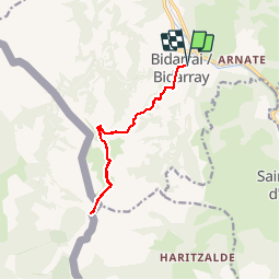

Lengte
12,4 km

Max. hoogte
951 m

Positief hoogteverschil
825 m
Km-Effort
23 km

Min. hoogte
138 m

Negatief hoogteverschil
825 m
Boucle
Ja
Datum van aanmaak :
2016-07-31 00:00:00.0
Laatste wijziging :
2016-07-31 00:00:00.0
2h20
Moeilijkheid : Medium

Gratisgps-wandelapplicatie
 SityTrail
IGN / Geografische instituten
SityTrail Plus
De wereld gaat voor u open
Over ons
Tocht Lopen van 12,4 km beschikbaar op Nieuw-Aquitanië, Pyrénées-Atlantiques, Bidarray. Deze tocht wordt voorgesteld door funkady.
Plaatsbepaling
Land:
France
Regio :
Nieuw-Aquitanië
Departement/Provincie :
Pyrénées-Atlantiques
Gemeente :
Bidarray
Locatie:
Unknown
Vertrek:(Dec)
Vertrek:(UTM)
634071 ; 4791649 (30T) N.
Opmerkingen