


Nohant

jlrayon
Gebruiker
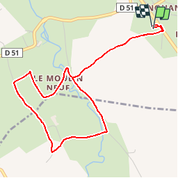

Lengte
5,2 km

Max. hoogte
212 m

Positief hoogteverschil
55 m
Km-Effort
5,9 km

Min. hoogte
187 m

Negatief hoogteverschil
52 m
Boucle
Ja
Datum van aanmaak :
2016-08-19 00:00:00.0
Laatste wijziging :
2016-08-19 00:00:00.0
1h20
Moeilijkheid : Gemakkelijk

Gratisgps-wandelapplicatie
 SityTrail
IGN / Geografische instituten
SityTrail Plus
De wereld gaat voor u open
Over ons
Tocht Stappen van 5,2 km beschikbaar op Centre-Val de Loire, Indre, Nohant-Vic. Deze tocht wordt voorgesteld door jlrayon.
Beschrijving
Sur les pas de Georges Sand.
Balade en attendant les heures d'ouvertures de la maison de G.S.
Plaatsbepaling
Land:
France
Regio :
Centre-Val de Loire
Departement/Provincie :
Indre
Gemeente :
Nohant-Vic
Locatie:
Unknown
Vertrek:(Dec)
Vertrek:(UTM)
421441 ; 5163937 (31T) N.
Opmerkingen