


st michel along canal

norman0000
Gebruiker
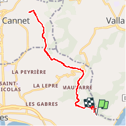

Lengte
10,9 km

Max. hoogte
184 m

Positief hoogteverschil
197 m
Km-Effort
13,5 km

Min. hoogte
90 m

Negatief hoogteverschil
191 m
Boucle
Ja
Datum van aanmaak :
2016-09-17 00:00:00.0
Laatste wijziging :
2016-09-17 00:00:00.0
2h13
Moeilijkheid : Onbekend

Gratisgps-wandelapplicatie
 SityTrail
IGN / Geografische instituten
SityTrail Plus
De wereld gaat voor u open
Over ons
Tocht Stappen van 10,9 km beschikbaar op Provence-Alpes-Côte d'Azur, Alpes-Maritimes, Cannes. Deze tocht wordt voorgesteld door norman0000.
Beschrijving
From outside St. Michel apartments up steep hill then flat. Return by same route.
Plaatsbepaling
Land:
France
Regio :
Provence-Alpes-Côte d'Azur
Departement/Provincie :
Alpes-Maritimes
Gemeente :
Cannes
Locatie:
Unknown
Vertrek:(Dec)
Vertrek:(UTM)
342444 ; 4823967 (32T) N.
Opmerkingen