


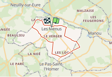
Les Menus 12

togolo28
Gebruiker

Lengte
12 km

Max. hoogte
224 m

Positief hoogteverschil
58 m
Km-Effort
12,8 km

Min. hoogte
210 m

Negatief hoogteverschil
58 m
Boucle
Ja
Datum van aanmaak :
2016-10-04 00:00:00.0
Laatste wijziging :
2016-10-04 00:00:00.0
2h50
Moeilijkheid : Gemakkelijk

Gratisgps-wandelapplicatie
 SityTrail
IGN / Geografische instituten
SityTrail Plus
De wereld gaat voor u open
Over ons
Tocht Stappen van 12 km beschikbaar op Normandië, Orne, Les Menus. Deze tocht wordt voorgesteld door togolo28.
Plaatsbepaling
Land:
France
Regio :
Normandië
Departement/Provincie :
Orne
Gemeente :
Les Menus
Locatie:
Unknown
Vertrek:(Dec)
Vertrek:(UTM)
347415 ; 5376637 (31U) N.
Opmerkingen