


69 chiroubles reel

trietsch
Gebruiker
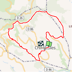

Lengte
10 km

Max. hoogte
563 m

Positief hoogteverschil
313 m
Km-Effort
14,2 km

Min. hoogte
310 m

Negatief hoogteverschil
312 m
Boucle
Ja
Datum van aanmaak :
2016-11-01 00:00:00.0
Laatste wijziging :
2020-01-04 20:29:29.857
3h48
Moeilijkheid : Medium

Gratisgps-wandelapplicatie
 SityTrail
IGN / Geografische instituten
SityTrail Plus
De wereld gaat voor u open
Over ons
Tocht Stappen van 10 km beschikbaar op Auvergne-Rhône-Alpes, Rhône, Chiroubles. Deze tocht wordt voorgesteld door trietsch.


Plaatsbepaling
Land:
France
Regio :
Auvergne-Rhône-Alpes
Departement/Provincie :
Rhône
Gemeente :
Chiroubles
Locatie:
Unknown
Vertrek:(Dec)
Vertrek:(UTM)
628518 ; 5115403 (31T) N.
Opmerkingen