


Match circuit jeudi moyen

labotte
Gebruiker

Lengte
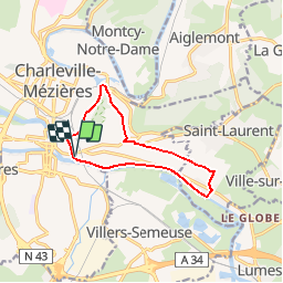
9,6 km

Max. hoogte
218 m

Positief hoogteverschil
126 m
Km-Effort
11,3 km

Min. hoogte
139 m

Negatief hoogteverschil
128 m
Boucle
Ja
Datum van aanmaak :
2018-07-31 13:36:02.957
Laatste wijziging :
2018-07-31 13:36:02.969
2h30
Moeilijkheid : Gemakkelijk

Gratisgps-wandelapplicatie
 SityTrail
IGN / Geografische instituten
SityTrail Plus
De wereld gaat voor u open
Over ons
Tocht Stappen van 9,6 km beschikbaar op Grand Est, Ardennes, Charleville-Mézières. Deze tocht wordt voorgesteld door labotte.
Plaatsbepaling
Land:
France
Regio :
Grand Est
Departement/Provincie :
Ardennes
Gemeente :
Charleville-Mézières
Locatie:
Unknown
Vertrek:(Dec)
Vertrek:(UTM)
624342 ; 5513170 (31U) N.
Opmerkingen