Tocht Stappen Sorède - RP66 SOREDE VALLÉE HEUREUSE - COL DES 4 TERMES - LE 17.11.2016  - Photo

RP66 SOREDE VALLÉE HEUREUSE - COL DES 4 TERMES - LE 17.11.2016

 jeff66
jeff66

Gebruiker

© OpenStreetMap contributors
Lengte
Lengte
19,4 km
Max. hoogte
Max. hoogte
1163 m
Positief hoogteverschil
1043 m
Km-Effort
Km-Effort  
33 km
Min. hoogte
Min. hoogte
202 m
Negatief hoogteverschil
1044 m
Boucle
Boucle
Ja
Datum van aanmaak :
2016-11-18 00:00:00.0
Laatste wijziging :
2016-11-18 00:00:00.0

(2 Bericht)

Stappen
Stappen
5h26
Moeilijkheid : Moeilijk

Scan deze QR-code om de tocht te openen in de SityTrail-applicatie

Gratisgps-wandelapplicatie

Logo SityTrail SityTrail

IGN / Geografische instituten

SityTrail uit de App Store downloaden SityTrail uit Google Play downloaden

Logo SityTrail SityTrail Plus

De wereld gaat voor u open

SityTrail uit de App Store downloaden SityTrail uit Google Play downloaden SityTrail op Huawei AppGallery downloaden

Over ons

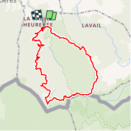
Tocht Stappen van 19,4 km beschikbaar op Occitanië, Pyrénées-Orientales, Sorède. Deze tocht wordt voorgesteld door jeff66.

Beschrijving

RP66 SOREDE VALLÉE HEUREUSE - COL DES 4 TERMES - LE 17.11.2016 PAR col de Lespinas - pic de les mèdes - col de l'aranyo - col des 3 hêtres - col des 4 termes - col de l'estaque - font del l'Orry - piste forestière

Hoogteprofiel

Plaatsbepaling

Land:
France
Regio :
Occitanië
Departement/Provincie :
Pyrénées-Orientales
Gemeente :
Sorède
Locatie:
Unknown
Vertrek:(Dec)
Vertrek:(UTM)
497230 ; 4706104 (31T) N.

Opmerkingen

Gelieve in te loggen om een commentaar of een beoordeling achter te laten


essai 33


Sluiten
Mijn abonnementen