


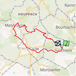
Sentheim - Masevaux - Sentheim

patrickbeyrath
Gebruiker

Lengte
13,5 km

Max. hoogte
529 m

Positief hoogteverschil
271 m
Km-Effort
17,1 km

Min. hoogte
353 m

Negatief hoogteverschil
272 m
Boucle
Ja
Datum van aanmaak :
2018-10-13 05:52:20.464
Laatste wijziging :
2018-10-13 05:52:20.472
3h46
Moeilijkheid : Gemakkelijk

Gratisgps-wandelapplicatie
 SityTrail
IGN / Geografische instituten
SityTrail Plus
De wereld gaat voor u open
Over ons
Tocht Stappen van 13,5 km beschikbaar op Grand Est, Haut-Rhin, Sentheim. Deze tocht wordt voorgesteld door patrickbeyrath.
Plaatsbepaling
Land:
France
Regio :
Grand Est
Departement/Provincie :
Haut-Rhin
Gemeente :
Sentheim
Locatie:
Unknown
Vertrek:(Dec)
Vertrek:(UTM)
353993 ; 5290979 (32T) N.
Opmerkingen