Tocht Noords wandelen Sevrey - sevrey - Photo
 patourad
patourad

Gebruiker

© OpenStreetMap contributors
Lengte
Lengte
9,7 km
Max. hoogte
Max. hoogte
204 m
Positief hoogteverschil
42 m
Km-Effort
Km-Effort  
10,2 km
Min. hoogte
Min. hoogte
188 m
Negatief hoogteverschil
43 m
Boucle
Boucle
Ja
Datum van aanmaak :
2016-11-28 00:00:00.0
Laatste wijziging :
2016-11-28 00:00:00.0

(1 Bericht)

Noords wandelen
Noords wandelen
1h37
Moeilijkheid : Onbekend

Scan deze QR-code om de tocht te openen in de SityTrail-applicatie

Gratisgps-wandelapplicatie

Logo SityTrail SityTrail

IGN / Geografische instituten

SityTrail uit de App Store downloaden SityTrail uit Google Play downloaden

Logo SityTrail SityTrail World

De wereld gaat voor u open

SityTrail uit de App Store downloaden SityTrail uit Google Play downloaden SityTrail op Huawei AppGallery downloaden

Over ons

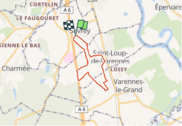
Tocht Noords wandelen van 9,7 km beschikbaar op Bourgondië-Franche-Comté, Saône-et-Loire, Sevrey. Deze tocht wordt voorgesteld door patourad.

Beschrijving

facile

Hoogteprofiel

Plaatsbepaling

Land:
France
Regio :
Bourgondië-Franche-Comté
Departement/Provincie :
Saône-et-Loire
Gemeente :
Sevrey
Locatie:
Unknown
Vertrek:(Dec)
Vertrek:(UTM)
640450 ; 5177417 (31T) N.

Opmerkingen

Gelieve in te loggen om een commentaar of een beoordeling achter te laten


Wandeltochten in de omgeving

Tocht Mountainbike Chalon-sur-Saône - rando chaumes de givry av christppher - Photo
Mountainbike
margotjl

Mountainbike

Medium
(1)
Chalon-sur-Saône, Bourgondië-Franche-Comté, Saône-et-Loire, France
31 km | 38 km-effort
2h 59min
Ja
Tocht Fiets Lux - LUX LA SAÔNE - Photo
Fiets
doclocjl

Fiets

Heel gemakkelijk
Lux, Bourgondië-Franche-Comté, Saône-et-Loire, France
7,7 km | 8,4 km-effort
1h 52min
Ja
Tocht Stappen Lux - Lux : la Saône  - Photo
Stappen
Brougeons

Stappen

Heel gemakkelijk
Lux, Bourgondië-Franche-Comté, Saône-et-Loire, France
9,2 km | 10 km-effort
2h 14min
Ja
Tocht Stappen La Charmée - la charmée - Photo
Stappen
tountouri

Stappen

Medium
La Charmée, Bourgondië-Franche-Comté, Saône-et-Loire, France
5,7 km | 6,2 km-effort
1h 17min
Neen
Tocht Wegfiets Chalon-sur-Saône - Vélo Barizey...  - Photo
Wegfiets
jacques49

Wegfiets

Moeilijk
Chalon-sur-Saône, Bourgondië-Franche-Comté, Saône-et-Loire, France
48 km | 55 km-effort
2h 59min
Ja
Tocht Stappen Saint-Marcel - P . St Marcel - voie verte - Epervans - Chateau de la motte - lans - les Riottis et retour par la pharmatie . - Photo
Stappen
jeanpaulcheyssac

Stappen

Medium
Saint-Marcel, Bourgondië-Franche-Comté, Saône-et-Loire, France
9,1 km | 9,7 km-effort
2h 12min
Ja
Tocht Te voet Chalon-sur-Saône - G . St Rémy - Vessey - Taisey - La Chaume - Californie - Les GD dix huits - Bas de l' hopital et retour aux Charreaux .  - Photo
Te voet
jeanpaulcheyssac

Te voet

Gemakkelijk
Chalon-sur-Saône, Bourgondië-Franche-Comté, Saône-et-Loire, France
10,4 km | 11,3 km-effort
2h 33min
Ja
Tocht Te voet Saint-Marcel - P . St Marcel - la Vacherie - les Orlans - le centre routier - ile du Boyau - Pont Nord - Prairie St Nicolas - retour par le Breuil .  - Photo
Te voet
jeanpaulcheyssac

Te voet

Gemakkelijk
Saint-Marcel, Bourgondië-Franche-Comté, Saône-et-Loire, France
9 km | 9,8 km-effort
2h 13min
Ja
Tocht Stappen Saint-Ambreuil - G . St Ambreuil - Carré aux loups - Les mouilles - Sommière de la GD Toile - Sommière de la Gd Manche - Retour  par St Eloi .  - Photo
Stappen
jeanpaulcheyssac

Stappen

Medium
Saint-Ambreuil, Bourgondië-Franche-Comté, Saône-et-Loire, France
10,8 km | 11,6 km-effort
2h 37min
Ja


Sluiten
Mijn abonnementen