


Jouhe 10.9km 20161129

cmike39
Gebruiker
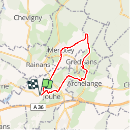

Lengte
10,9 km

Max. hoogte
317 m

Positief hoogteverschil
171 m
Km-Effort
13,2 km

Min. hoogte
228 m

Negatief hoogteverschil
172 m
Boucle
Ja
Datum van aanmaak :
2017-01-08 00:00:00.0
Laatste wijziging :
2017-01-08 00:00:00.0
2h15
Moeilijkheid : Onbekend

Gratisgps-wandelapplicatie
 SityTrail
IGN / Geografische instituten
SityTrail Plus
De wereld gaat voor u open
Over ons
Tocht Noords wandelen van 10,9 km beschikbaar op Bourgondië-Franche-Comté, Jura, Jouhe. Deze tocht wordt voorgesteld door cmike39.
Beschrijving
Enregistré le 29 11 206
Animateur Michel P.
et Michel C.
Plaatsbepaling
Land:
France
Regio :
Bourgondië-Franche-Comté
Departement/Provincie :
Jura
Gemeente :
Jouhe
Locatie:
Unknown
Vertrek:(Dec)
Vertrek:(UTM)
688362 ; 5223831 (31T) N.
Opmerkingen