Tocht Stappen Fors - Fors 9,7 km - Photo
 olaze
olaze

Gebruiker

© OpenStreetMap contributors
Lengte
Lengte
9,7 km
Max. hoogte
Max. hoogte
65 m
Positief hoogteverschil
59 m
Km-Effort
Km-Effort  
10,5 km
Min. hoogte
Min. hoogte
31 m
Negatief hoogteverschil
59 m
Boucle
Boucle
Ja
Datum van aanmaak :
2016-12-07 00:00:00.0
Laatste wijziging :
2016-12-07 00:00:00.0

(0 Bericht)

Stappen
Stappen
2h19
Moeilijkheid : Gemakkelijk

Scan deze QR-code om de tocht te openen in de SityTrail-applicatie

Gratisgps-wandelapplicatie

Logo SityTrail SityTrail

IGN / Geografische instituten

SityTrail uit de App Store downloaden SityTrail uit Google Play downloaden

Logo SityTrail SityTrail World

De wereld gaat voor u open

SityTrail uit de App Store downloaden SityTrail uit Google Play downloaden SityTrail op Huawei AppGallery downloaden

Over ons

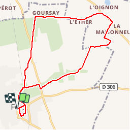
Tocht Stappen van 9,7 km beschikbaar op Nieuw-Aquitanië, Deux-Sèvres, Fors. Deze tocht wordt voorgesteld door olaze.

Beschrijving

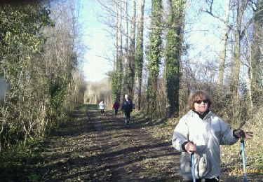
Randonnée autour de Fors.sur chemins et petites routes . Campagne .Club rando Bessines 12/2016. Départ parking mairie ou parking église .

Hoogteprofiel

Foto's

Plaatsbepaling

Land:
France
Regio :
Nieuw-Aquitanië
Departement/Provincie :
Deux-Sèvres
Gemeente :
Fors
Locatie:
Unknown
Vertrek:(Dec)
Vertrek:(UTM)
699682 ; 5123401 (30T) N.

Wandeltochten in de omgeving

Tocht Stappen Fors - Les Sanguinières circuit  7Km - Photo
Stappen
olaze

Stappen

Gemakkelijk
Fors, Nieuw-Aquitanië, Deux-Sèvres, France
8,9 km | 9,4 km-effort
1h 40min
Ja
Tocht Stappen Fors - Les Sanguinières circuit 2 - Photo
Stappen
olaze

Stappen

Gemakkelijk
Fors, Nieuw-Aquitanië, Deux-Sèvres, France
8,9 km | 9,5 km-effort
2h 6min
Ja
Tocht Stappen Granzay-Gript - Gript-8,5km-01_2014 - Photo
Stappen
olaze

Stappen

Heel gemakkelijk
Granzay-Gript, Nieuw-Aquitanië, Deux-Sèvres, France
8,5 km | 9 km-effort
2h 0min
Ja
Tocht Wegfiets Saint-Martin-de-Bernegoue - Lambon 46 km - Photo
Wegfiets
toff79

Wegfiets

Moeilijk
Saint-Martin-de-Bernegoue, Nieuw-Aquitanië, Deux-Sèvres, France
46 km | 51 km-effort
2h 0min
Ja
Tocht Wegfiets Saint-Martin-de-Bernegoue - Pérignee vauballier aiffres  - Photo
Wegfiets
toff79

Wegfiets

Gemakkelijk
Saint-Martin-de-Bernegoue, Nieuw-Aquitanië, Deux-Sèvres, France
40 km | 43 km-effort
1h 41min
Ja
Tocht Wegfiets Saint-Martin-de-Bernegoue - Boucle autour de Bernegoue  - Photo
Wegfiets
toff79

Wegfiets

Medium
Saint-Martin-de-Bernegoue, Nieuw-Aquitanië, Deux-Sèvres, France
32 km | 35 km-effort
1h 24min
Ja
Tocht Stappen Fors - Les Sanguinières - Photo
Stappen
olaze

Stappen

Heel gemakkelijk
Fors, Nieuw-Aquitanië, Deux-Sèvres, France
7 km | 7,3 km-effort
1h 38min
Ja
Tocht Stappen Marigny - Marigny - Photo
Stappen
olaze

Stappen

Gemakkelijk
Marigny, Nieuw-Aquitanië, Deux-Sèvres, France
7,8 km | 8,6 km-effort
2h 7min
Ja
Tocht Stappen Granzay-Gript - GRIPT 19/04/2011 - Photo
Stappen
olaze

Stappen

Gemakkelijk
Granzay-Gript, Nieuw-Aquitanië, Deux-Sèvres, France
8,5 km | 9 km-effort
2h 20min
Ja


Sluiten
Mijn abonnementen