Tocht Andere activiteiten Échauffour - Basse Normandie - Ligne 402 - Sainte-Gauburge - Mesnil-Mauger - Photo

Basse Normandie - Ligne 402 - Sainte-Gauburge - Mesnil-Mauger

 mich54
mich54

Gebruiker

© OpenStreetMap contributors
Lengte
Lengte
61 km
Max. hoogte
Max. hoogte
317 m
Positief hoogteverschil
347 m
Km-Effort
Km-Effort  
66 km
Min. hoogte
Min. hoogte
19 m
Negatief hoogteverschil
578 m
Boucle
Boucle
Neen
Datum van aanmaak :
2017-01-22 00:00:00.0
Laatste wijziging :
2017-01-22 00:00:00.0

(0 Bericht)

Andere activiteiten
Andere activiteiten
5m
Moeilijkheid : Onbekend

Scan deze QR-code om de tocht te openen in de SityTrail-applicatie

Gratisgps-wandelapplicatie

Logo SityTrail SityTrail

IGN / Geografische instituten

SityTrail uit de App Store downloaden SityTrail uit Google Play downloaden

Logo SityTrail SityTrail World

De wereld gaat voor u open

SityTrail uit de App Store downloaden SityTrail uit Google Play downloaden SityTrail op Huawei AppGallery downloaden

Over ons

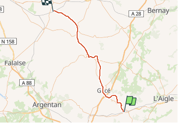
Tocht Andere activiteiten van 61 km beschikbaar op Normandië, Orne, Échauffour. Deze tocht wordt voorgesteld door mich54.

Beschrijving

La ligne de Sainte-Gauburge au Mesnil-Mauger est une ancienne ligne de chemin de fer française reliant Sainte-Gauburge-Sainte-Colombe, dans le département de l'Orne, au Mesnil-Mauger, dans le Calvados, en région Basse-Normandie.
Aujourd'hui, la ligne est maintenant transformée en voie verte, appelée la Coulée verte, de Vimoutiers au Mesnil-Mauger. S'y déroule annuellement la course pédestre des foulées du Terroir entre Livarot et Vimoutiers.(Source Wikipédia)

Hoogteprofiel

Plaatsbepaling

Land:
France
Regio :
Normandië
Departement/Provincie :
Orne
Gemeente :
Échauffour
Locatie:
Unknown
Vertrek:(Dec)
Vertrek:(UTM)
309374 ; 5399106 (31U) N.

Wandeltochten in de omgeving

Tocht Auto La Genevraie - 2023-03-01 maheru Vdu P - Photo
Auto
patrick2m

Auto

La Genevraie, Normandië, Orne, France
43 km | 49 km-effort
2h 30min
Neen
Tocht Andere activiteiten Échauffour - Haute Normandie - Ligne 400 - Echauffour - Bernay (Section de Echauffour à la limite Eure/Orne) 1 - Photo
Andere activiteiten
mich54

Andere activiteiten

Heel gemakkelijk
Échauffour, Normandië, Orne, France
18,7 km | 21 km-effort
5min
Neen
Tocht Fiets Échauffour - EchauSolignyEvroult - Photo
Fiets
sylvain75

Fiets

Gemakkelijk
Échauffour, Normandië, Orne, France
73 km | 85 km-effort
3h 0min
Ja
Tocht Fiets Échauffour - Autour de Gacé - Photo
Fiets
sylvain75

Fiets

Medium
Échauffour, Normandië, Orne, France
69 km | 80 km-effort
4h 38min
Ja
Tocht Fiets Échauffour - echauf_char_touq_har - Photo
Fiets
sylvain75

Fiets

Medium
Échauffour, Normandië, Orne, France
108 km | 125 km-effort
Onbekend
Ja
Tocht Fiets Échauffour - champs haut gacé - Photo
Fiets
sylvain75

Fiets

Gemakkelijk
Échauffour, Normandië, Orne, France
32 km | 38 km-effort
1h 19min
Ja
Tocht Fiets Échauffour - Vélo - Photo
Fiets
sylvain75

Fiets

Heel gemakkelijk
Échauffour, Normandië, Orne, France
68 km | 79 km-effort
Onbekend
Ja


Sluiten
Mijn abonnementen