


stanneux nord est

Mullender
Gebruiker
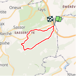

Lengte
8,2 km

Max. hoogte
373 m

Positief hoogteverschil
245 m
Km-Effort
11,5 km

Min. hoogte
192 m

Negatief hoogteverschil
243 m
Boucle
Ja
Datum van aanmaak :
2017-01-25 00:00:00.0
Laatste wijziging :
2017-01-25 00:00:00.0
1h51
Moeilijkheid : Medium

Gratisgps-wandelapplicatie
 SityTrail
IGN / Geografische instituten
SityTrail Plus
De wereld gaat voor u open
Over ons
Tocht Stappen van 8,2 km beschikbaar op Wallonië, Luik, Theux. Deze tocht wordt voorgesteld door Mullender.
Plaatsbepaling
Land:
Belgium
Regio :
Wallonië
Departement/Provincie :
Luik
Gemeente :
Theux
Locatie:
Polleur
Vertrek:(Dec)
Vertrek:(UTM)
703965 ; 5601921 (31U) N.
Opmerkingen