Tocht Mountainbike Agen-d'Aveyron - Les Palanges 1 - Photo
 bonnetchristian
bonnetchristian

Gebruiker

© OpenStreetMap contributors
Lengte
Lengte
10 km
Max. hoogte
Max. hoogte
869 m
Positief hoogteverschil
186 m
Km-Effort
Km-Effort  
12,4 km
Min. hoogte
Min. hoogte
775 m
Negatief hoogteverschil
183 m
Boucle
Boucle
Ja
Datum van aanmaak :
2014-12-10 00:00:00.0
Laatste wijziging :
2014-12-10 00:00:00.0

(1 Bericht)

Mountainbike
Mountainbike
--
Moeilijkheid : Onbekend

Scan deze QR-code om de tocht te openen in de SityTrail-applicatie

Gratisgps-wandelapplicatie

Logo SityTrail SityTrail

IGN / Geografische instituten

SityTrail uit de App Store downloaden SityTrail uit Google Play downloaden

Logo SityTrail SityTrail World

De wereld gaat voor u open

SityTrail uit de App Store downloaden SityTrail uit Google Play downloaden SityTrail op Huawei AppGallery downloaden

Over ons

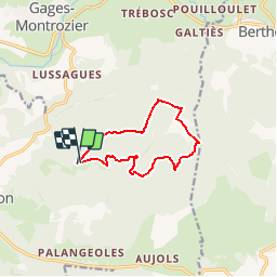
Tocht Mountainbike van 10 km beschikbaar op Occitanië, Aveyron, Agen-d'Aveyron. Deze tocht wordt voorgesteld door bonnetchristian.

Beschrijving

En forêt, parfois un peu de pente.... En saison, à travers bois après la pluie, des cèpes tête noire !

Hoogteprofiel

Plaatsbepaling

Land:
France
Regio :
Occitanië
Departement/Provincie :
Aveyron
Gemeente :
Agen-d'Aveyron
Locatie:
Unknown
Vertrek:(Dec)
Vertrek:(UTM)
477192 ; 4912313 (31T) N.

Opmerkingen

Gelieve in te loggen om een commentaar of een beoordeling achter te laten


passage dans la propriété privé du mas Berthier


Wandeltochten in de omgeving

Tocht Moto-cross Montrozier - av cl 2024 - Photo
Moto-cross
frank12

Moto-cross

Heel gemakkelijk
Montrozier, Occitanië, Aveyron, France
30 km | 42 km-effort
1h 0min
Neen
Tocht Mountainbike Montrozier - VTT Gages-Palanges Magalie 38km 750D+ 2021-06-19 - Photo
Mountainbike
Levillefranchois

Mountainbike

Medium
Montrozier, Occitanië, Aveyron, France
38 km | 47 km-effort
Onbekend
Ja
Tocht Stappen Montrozier - Gages Campeyroux - Photo
Stappen
Rere1947

Stappen

Montrozier, Occitanië, Aveyron, France
8,4 km | 9,7 km-effort
1h 52min
Ja
Tocht Mountainbike Bertholène - ancienne voie ferrée - Photo
Mountainbike
bbertrand974

Mountainbike

Heel gemakkelijk
Bertholène, Occitanië, Aveyron, France
22 km | 26 km-effort
1h 42min
Neen
Tocht Mountainbike Montrozier - Gages - Photo
Mountainbike
bonnetchristian

Mountainbike

Heel gemakkelijk
Montrozier, Occitanië, Aveyron, France
4,7 km | 6 km-effort
Onbekend
Ja
Tocht Stappen La Loubière - Ortholes - Canabols - Photo
Stappen
bonnetchristian

Stappen

Heel gemakkelijk
La Loubière, Occitanië, Aveyron, France
8,4 km | 10 km-effort
Onbekend
Ja
Tocht Mountainbike Agen-d'Aveyron - Les Palanges 2 - Photo
Mountainbike
bonnetchristian

Mountainbike

Heel gemakkelijk
Agen-d'Aveyron, Occitanië, Aveyron, France
13,2 km | 16,6 km-effort
Onbekend
Ja
Tocht Mountainbike La Loubière - Campeyroux - Photo
Mountainbike
bonnetchristian

Mountainbike

Heel gemakkelijk
La Loubière, Occitanië, Aveyron, France
5 km | 5,8 km-effort
Onbekend
Ja
Tocht Moto-cross Montrozier - essai av. cl.2024 - Photo
Moto-cross
frank12

Moto-cross

Heel gemakkelijk
Montrozier, Occitanië, Aveyron, France
26 km | 0 m-effort
1h 7min
Neen


Sluiten
Mijn abonnementen