


Xhoris ADEPS

mauZ
Gebruiker
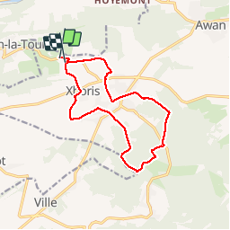

Lengte
12,5 km

Max. hoogte
356 m

Positief hoogteverschil
236 m
Km-Effort
15,6 km

Min. hoogte
216 m

Negatief hoogteverschil
225 m
Boucle
Ja
Datum van aanmaak :
2017-01-29 00:00:00.0
Laatste wijziging :
2017-01-29 00:00:00.0
2h41
Moeilijkheid : Heel gemakkelijk

Gratisgps-wandelapplicatie
 SityTrail
IGN / Geografische instituten
SityTrail Plus
De wereld gaat voor u open
Over ons
Tocht Andere activiteiten van 12,5 km beschikbaar op Wallonië, Luik, Ferrières. Deze tocht wordt voorgesteld door mauZ.
Beschrijving
Sympa seule difficulté : gadoue gadoue gadoue ou neige fondante et glissante
Plaatsbepaling
Land:
Belgium
Regio :
Wallonië
Departement/Provincie :
Luik
Gemeente :
Ferrières
Locatie:
Xhoris
Vertrek:(Dec)
Vertrek:(UTM)
684109 ; 5592085 (31U) N.
Opmerkingen