


RP66 CANET EN ROUSSILLON - LE PORT - FRONT DE MER - Village - le 10.02.2017

jeff66
Gebruiker
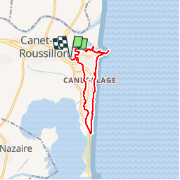

Lengte
11,6 km

Max. hoogte
12 m

Positief hoogteverschil
55 m
Km-Effort
12,3 km

Min. hoogte
-2 m

Negatief hoogteverschil
55 m
Boucle
Ja
Datum van aanmaak :
2017-02-10 00:00:00.0
Laatste wijziging :
2017-02-10 00:00:00.0
2h20
Moeilijkheid : Gemakkelijk

Gratisgps-wandelapplicatie
 SityTrail
IGN / Geografische instituten
SityTrail Plus
De wereld gaat voor u open
Over ons
Tocht Stappen van 11,6 km beschikbaar op Occitanië, Pyrénées-Orientales, Canet-en-Roussillon. Deze tocht wordt voorgesteld door jeff66.
Beschrijving
RP66 CANET EN ROUSSILLON - LE PORT - FRONT DE MER - Village - le 10.02.2017
Plaatsbepaling
Land:
France
Regio :
Occitanië
Departement/Provincie :
Pyrénées-Orientales
Gemeente :
Canet-en-Roussillon
Locatie:
Unknown
Vertrek:(Dec)
Vertrek:(UTM)
501917 ; 4727496 (31T) N.
Opmerkingen