


sortie vtt du 12022017

fabwin
Gebruiker GUIDE
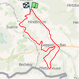

Lengte
33 km

Max. hoogte
447 m

Positief hoogteverschil
421 m
Km-Effort
39 km

Min. hoogte
327 m

Negatief hoogteverschil
420 m
Boucle
Ja
Datum van aanmaak :
2017-02-16 00:00:00.0
Laatste wijziging :
2017-02-16 00:00:00.0
2h04
Moeilijkheid : Gemakkelijk

Gratisgps-wandelapplicatie
 SityTrail
IGN / Geografische instituten
SityTrail Plus
De wereld gaat voor u open
Over ons
Tocht Mountainbike van 33 km beschikbaar op Grand Est, Haut-Rhin, Mertzen. Deze tocht wordt voorgesteld door fabwin.
Beschrijving
Sortie sous le soleil avec papa & Ange.
Ange a pédalé un peu plus que nous dû au fait que le frein avant du Spé freinait en permanence!!!
Plaatsbepaling
Land:
France
Regio :
Grand Est
Departement/Provincie :
Haut-Rhin
Gemeente :
Mertzen
Locatie:
Unknown
Vertrek:(Dec)
Vertrek:(UTM)
358944 ; 5272168 (32T) N.
Opmerkingen