


de Fuveau à Beldodene

ARPF
Gebruiker
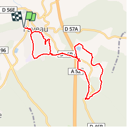

Lengte
9,1 km

Max. hoogte
357 m

Positief hoogteverschil
175 m
Km-Effort
11,5 km

Min. hoogte
251 m

Negatief hoogteverschil
175 m
Boucle
Ja
Datum van aanmaak :
2017-03-06 00:00:00.0
Laatste wijziging :
2017-03-06 00:00:00.0
2h27
Moeilijkheid : Gemakkelijk
Gratisgps-wandelapplicatie
 SityTrail
IGN / Geografische instituten
SityTrail Plus
De wereld gaat voor u open
Over ons
Tocht Stappen van 9,1 km beschikbaar op Provence-Alpes-Côte d'Azur, Bouches-du-Rhône, Fuveau. Deze tocht wordt voorgesteld door ARPF.
Beschrijving
Départ du parking Guérin-Marchi passage à proximité du collège de Fuveau -Traversée au dessus de l'autoroute - direction le Chalet Suisse-retour par la Chapelle St Michel
Plaatsbepaling
Land:
France
Regio :
Provence-Alpes-Côte d'Azur
Departement/Provincie :
Bouches-du-Rhône
Gemeente :
Fuveau
Locatie:
Unknown
Vertrek:(Dec)
Vertrek:(UTM)
706879 ; 4814419 (31T) N.
Opmerkingen