


L'ÉBRALDIFONTAIN

laoj
Gebruiker

Lengte
38 km

Max. hoogte
119 m

Positief hoogteverschil
550 m
Km-Effort
45 km

Min. hoogte
40 m

Negatief hoogteverschil
540 m
Boucle
Ja
Datum van aanmaak :
2017-03-13 00:00:00.0
Laatste wijziging :
2017-03-13 00:00:00.0
2h56
Moeilijkheid : Moeilijk

Gratisgps-wandelapplicatie
 SityTrail
IGN / Geografische instituten
SityTrail Plus
De wereld gaat voor u open
Over ons
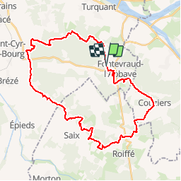
Tocht Mountainbike van 38 km beschikbaar op Pays de la Loire, Maine-et-Loire, Fontevraud-l'Abbaye. Deze tocht wordt voorgesteld door laoj.
Beschrijving
LE TOUR DU CAMP MILITAIRE DE FONTEVRAUD L'ABBAYE
Plaatsbepaling
Land:
France
Regio :
Pays de la Loire
Departement/Provincie :
Maine-et-Loire
Gemeente :
Fontevraud-l'Abbaye
Locatie:
Unknown
Vertrek:(Dec)
Vertrek:(UTM)
275449 ; 5229789 (31T) N.
Opmerkingen