


Arcangues Arbonne

DECHAMPD
Gebruiker
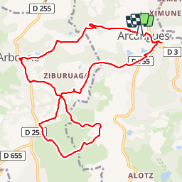

Lengte
12 km

Max. hoogte
82 m

Positief hoogteverschil
219 m
Km-Effort
15 km

Min. hoogte
13 m

Negatief hoogteverschil
220 m
Boucle
Ja
Datum van aanmaak :
2019-01-14 17:30:53.771
Laatste wijziging :
2019-01-14 17:30:53.839
3h13
Moeilijkheid : Heel gemakkelijk

Gratisgps-wandelapplicatie
 SityTrail
IGN / Geografische instituten
SityTrail Plus
De wereld gaat voor u open
Over ons
Tocht Stappen van 12 km beschikbaar op Nieuw-Aquitanië, Pyrénées-Atlantiques, Arcangues. Deze tocht wordt voorgesteld door DECHAMPD.
Beschrijving
itinéraire agréable alterne entre prairie et sous bois.la nature de la végétation indique que l'eau est présente en abondance dans le sol
très beaux panoramas sur la montagne.


Plaatsbepaling
Land:
France
Regio :
Nieuw-Aquitanië
Departement/Provincie :
Pyrénées-Atlantiques
Gemeente :
Arcangues
Locatie:
Unknown
Vertrek:(Dec)
Vertrek:(UTM)
619509 ; 4810354 (30T) N.
Opmerkingen