


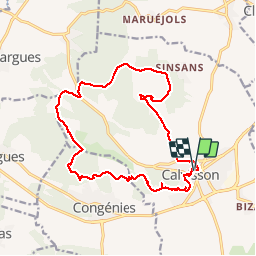
Calvisson les garrigues gardoises

grageot
Gebruiker

Lengte
17,5 km

Max. hoogte
207 m

Positief hoogteverschil
361 m
Km-Effort
22 km

Min. hoogte
55 m

Negatief hoogteverschil
360 m
Boucle
Ja
Datum van aanmaak :
2017-03-31 00:00:00.0
Laatste wijziging :
2017-03-31 00:00:00.0
4h50
Moeilijkheid : Gemakkelijk

Gratisgps-wandelapplicatie
 SityTrail
IGN / Geografische instituten
SityTrail Plus
De wereld gaat voor u open
Over ons
Tocht Stappen van 17,5 km beschikbaar op Occitanië, Gard, Calvisson. Deze tocht wordt voorgesteld door grageot.
Beschrijving
Une ballade sans difficulté, attention à l'orientation il y a des chemins partout non repris sur la carte.
De beaux panoramas sur la plaine
Plaatsbepaling
Land:
France
Regio :
Occitanië
Departement/Provincie :
Gard
Gemeente :
Calvisson
Locatie:
Unknown
Vertrek:(Dec)
Vertrek:(UTM)
595839 ; 4848849 (31T) N.
Opmerkingen