


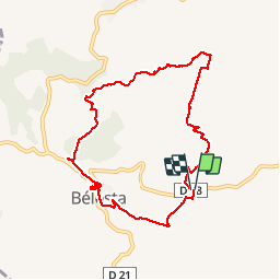
RP66 BELESTA - Ravin de l'Orteill - Dolmen - piste DFCI F135 - chapelle Saint Barthélémy - pic Aubeill

jeff66
Gebruiker


2h03
Moeilijkheid : Medium

Gratisgps-wandelapplicatie
 SityTrail
IGN / Geografische instituten
SityTrail Plus
De wereld gaat voor u open
Over ons
Tocht Stappen van 9,2 km beschikbaar op Occitanië, Pyrénées-Orientales, Bélesta. Deze tocht wordt voorgesteld door jeff66.
Beschrijving
RP66 BELESTA - parking à proximité ponts et RD38 - Ravin de l'Orteill - BELESTA - église - Ruelles - cave Coop - Dolmen - piste DFCI F135 - chapelle Saint Barthélémy - pic Aubeill - les roques planes - piste DFCI F135 - le 14.04.2017
Plaatsbepaling
Opmerkingen