


2017-04-23 Picnic CVA Sentier des Geants Wisches Opt01

holtzv
Gebruiker GUIDE
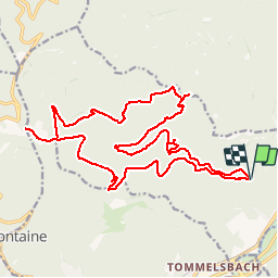

Lengte
22 km

Max. hoogte
870 m

Positief hoogteverschil
741 m
Km-Effort
32 km

Min. hoogte
364 m

Negatief hoogteverschil
741 m
Boucle
Ja
Datum van aanmaak :
2017-04-17 00:00:00.0
Laatste wijziging :
2017-04-17 00:00:00.0
3h57
Moeilijkheid : Medium

Gratisgps-wandelapplicatie
 SityTrail
IGN / Geografische instituten
SityTrail Plus
De wereld gaat voor u open
Over ons
Tocht Paard van 22 km beschikbaar op Grand Est, Bas-Rhin, Wisches. Deze tocht wordt voorgesteld door holtzv.


Plaatsbepaling
Land:
France
Regio :
Grand Est
Departement/Provincie :
Bas-Rhin
Gemeente :
Wisches
Locatie:
Unknown
Vertrek:(Dec)
Vertrek:(UTM)
370144 ; 5373959 (32U) N.
Opmerkingen