


2017 04 rando pedestre Kruth

staubalex
Gebruiker
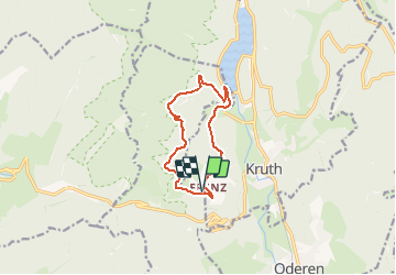

Lengte
9,9 km

Max. hoogte
942 m

Positief hoogteverschil
607 m
Km-Effort
18 km

Min. hoogte
525 m

Negatief hoogteverschil
607 m
Boucle
Ja
Datum van aanmaak :
2017-04-17 00:00:00.0
Laatste wijziging :
2017-04-17 00:00:00.0
3h44
Moeilijkheid : Gemakkelijk

Gratisgps-wandelapplicatie
 SityTrail
IGN / Geografische instituten
SityTrail Plus
De wereld gaat voor u open
Over ons
Tocht Stappen van 9,9 km beschikbaar op Grand Est, Haut-Rhin, Kruth. Deze tocht wordt voorgesteld door staubalex.
Plaatsbepaling
Land:
France
Regio :
Grand Est
Departement/Provincie :
Haut-Rhin
Gemeente :
Kruth
Locatie:
Unknown
Vertrek:(Dec)
Vertrek:(UTM)
346514 ; 5310090 (32T) N.
Opmerkingen