


FBBMP. Reid

mozzipsc
Gebruiker
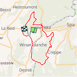

Lengte
13,5 km

Max. hoogte
394 m

Positief hoogteverschil
347 m
Km-Effort
18,2 km

Min. hoogte
218 m

Negatief hoogteverschil
347 m
Boucle
Ja
Datum van aanmaak :
2017-05-22 00:00:00.0
Laatste wijziging :
2017-05-22 00:00:00.0
3h55
Moeilijkheid : Heel gemakkelijk

Gratisgps-wandelapplicatie
 SityTrail
IGN / Geografische instituten
SityTrail Plus
De wereld gaat voor u open
Over ons
Tocht Stappen van 13,5 km beschikbaar op Wallonië, Luik, Theux. Deze tocht wordt voorgesteld door mozzipsc.
Beschrijving
TRès beau parcours à travers forêt, bois et campagne - dommage qu'on ne pourra pas la refaire, passant par un bois privé ! mais facilement contournable :-)
Plaatsbepaling
Land:
Belgium
Regio :
Wallonië
Departement/Provincie :
Luik
Gemeente :
Theux
Locatie:
La Reid
Vertrek:(Dec)
Vertrek:(UTM)
699745 ; 5596146 (31U) N.
Opmerkingen