


2017-07-09 Sortie CVA Lunaire

holtzv
Gebruiker GUIDE
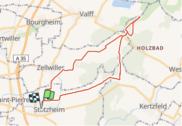

Lengte
16,8 km

Max. hoogte
170 m

Positief hoogteverschil
82 m
Km-Effort
17,9 km

Min. hoogte
151 m

Negatief hoogteverschil
79 m
Boucle
Ja
Datum van aanmaak :
2017-07-10 00:00:00.0
Laatste wijziging :
2017-07-10 00:00:00.0
2h17
Moeilijkheid : Gemakkelijk

Gratisgps-wandelapplicatie
 SityTrail
IGN / Geografische instituten
SityTrail Plus
De wereld gaat voor u open
Over ons
Tocht Paard van 16,8 km beschikbaar op Grand Est, Bas-Rhin, Stotzheim. Deze tocht wordt voorgesteld door holtzv.
Plaatsbepaling
Land:
France
Regio :
Grand Est
Departement/Provincie :
Bas-Rhin
Gemeente :
Stotzheim
Locatie:
Unknown
Vertrek:(Dec)
Vertrek:(UTM)
388383 ; 5359680 (32U) N.
Opmerkingen