


l'aupillon

Massiac15
Gebruiker
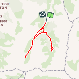

Lengte
13,4 km

Max. hoogte
2352 m

Positief hoogteverschil
668 m
Km-Effort
22 km

Min. hoogte
1877 m

Negatief hoogteverschil
680 m
Boucle
Ja
Datum van aanmaak :
2018-04-16 20:06:55.124
Laatste wijziging :
2018-04-16 20:06:55.124
6h27
Moeilijkheid : Gemakkelijk

Gratisgps-wandelapplicatie
 SityTrail
IGN / Geografische instituten
SityTrail Plus
De wereld gaat voor u open
Over ons
Tocht Stappen van 13,4 km beschikbaar op Provence-Alpes-Côte d'Azur, Hautes-Alpes, Les Orres. Deze tocht wordt voorgesteld door Massiac15.
Plaatsbepaling
Land:
France
Regio :
Provence-Alpes-Côte d'Azur
Departement/Provincie :
Hautes-Alpes
Gemeente :
Les Orres
Locatie:
Unknown
Vertrek:(Dec)
Vertrek:(UTM)
310096 ; 4928532 (32T) N.
Opmerkingen