


GENDRON-CELLES (Echelles)

GerardBouche
Gebruiker


2h58
Moeilijkheid : Medium

Gratisgps-wandelapplicatie
 SityTrail
IGN / Geografische instituten
SityTrail Plus
De wereld gaat voor u open
Over ons
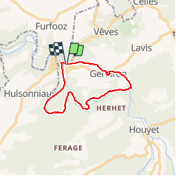
Tocht Stappen van 10,4 km beschikbaar op Wallonië, Namen, Houyet. Deze tocht wordt voorgesteld door GerardBouche.
Beschrijving
Depuis le P de l'Hôtel de la Lesse, un petit dénivelé en sous-bois avant d'atteindre le village de Gendron. La descente jusque l'Iwoigne (un petit ruisseau qui se jette, à cet endroit,dans la Lesse)est plutôt rocailleuse. La suite du parcours, en rive droite de la Lesse, est tout simplement superbe mais accidenté tout en restant ludique avec les quelques échelles à franchir.
Foto's
 - Photo 1")
 - Photo 2")
 - Photo 3")
 - Photo 4")
 - Photo 5")
 - Photo 6")
 - Photo 7")
Plaatsbepaling
Opmerkingen