


LE DOUBLE HUIT DE CHARLES

laoj
Gebruiker
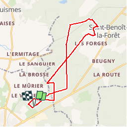

Lengte
14,9 km

Max. hoogte
129 m

Positief hoogteverschil
215 m
Km-Effort
17,7 km

Min. hoogte
62 m

Negatief hoogteverschil
217 m
Boucle
Ja
Datum van aanmaak :
2017-08-29 00:00:00.0
Laatste wijziging :
2017-08-29 00:00:00.0
1h10
Moeilijkheid : Gemakkelijk

Gratisgps-wandelapplicatie
 SityTrail
IGN / Geografische instituten
SityTrail Plus
De wereld gaat voor u open
Over ons
Tocht Mountainbike van 14,9 km beschikbaar op Centre-Val de Loire, Indre-et-Loire, Chinon. Deze tocht wordt voorgesteld door laoj.
Beschrijving
Ballade VTT en Forêt depuis le blanc carroi, le tracé suit principalement le GR3 pour aller à St benoit la forêt et au retour les routes forestières du bois de VILLIERS.
Plaatsbepaling
Land:
France
Regio :
Centre-Val de Loire
Departement/Provincie :
Indre-et-Loire
Gemeente :
Chinon
Locatie:
Unknown
Vertrek:(Dec)
Vertrek:(UTM)
293222 ; 5229384 (31T) N.
Opmerkingen