


Cascade de Runnes

phimar_2612
Gebruiker
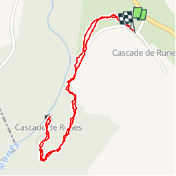

Lengte
1,4 km

Max. hoogte
1003 m

Positief hoogteverschil
69 m
Km-Effort
2,3 km

Min. hoogte
926 m

Negatief hoogteverschil
68 m
Boucle
Ja
Datum van aanmaak :
2018-04-16 22:23:36.485
Laatste wijziging :
2018-04-16 22:23:36.485
34m
Moeilijkheid : Medium

Gratisgps-wandelapplicatie
 SityTrail
IGN / Geografische instituten
SityTrail Plus
De wereld gaat voor u open
Over ons
Tocht Stappen van 1,4 km beschikbaar op Occitanië, Lozère, Pont de Montvert - Sud Mont Lozère. Deze tocht wordt voorgesteld door phimar_2612.
Plaatsbepaling
Land:
France
Regio :
Occitanië
Departement/Provincie :
Lozère
Gemeente :
Pont de Montvert - Sud Mont Lozère
Locatie:
Fraissinet-de-Lozère
Vertrek:(Dec)
Vertrek:(UTM)
553925 ; 4914402 (31T) N.
Opmerkingen