


Plage de Ramonette, Pointe de Bugul

patbt
Gebruiker
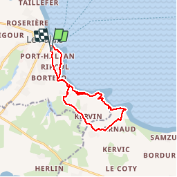

Lengte
13,5 km

Max. hoogte
53 m

Positief hoogteverschil
251 m
Km-Effort
16,9 km

Min. hoogte
0 m

Negatief hoogteverschil
255 m
Boucle
Ja
Datum van aanmaak :
2018-04-16 22:46:25.032
Laatste wijziging :
2018-04-16 22:46:25.032
6h32
Moeilijkheid : Medium

Gratisgps-wandelapplicatie
 SityTrail
IGN / Geografische instituten
SityTrail Plus
De wereld gaat voor u open
Over ons
Tocht Stappen van 13,5 km beschikbaar op Bretagne, Morbihan, Le Palais. Deze tocht wordt voorgesteld door patbt.
Plaatsbepaling
Land:
France
Regio :
Bretagne
Departement/Provincie :
Morbihan
Gemeente :
Le Palais
Locatie:
Unknown
Vertrek:(Dec)
Vertrek:(UTM)
488559 ; 5243280 (30T) N.
Opmerkingen