


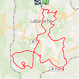
Labaroche - le Petit Hohnack - Obschel - retour par Labaroche Evaux - le Gazon et retour

patrickbeyrath
Gebruiker

Lengte
12,8 km

Max. hoogte
919 m

Positief hoogteverschil
423 m
Km-Effort
18,5 km

Min. hoogte
643 m

Negatief hoogteverschil
423 m
Boucle
Ja
Datum van aanmaak :
2018-10-13 05:52:00.291
Laatste wijziging :
2018-10-13 05:52:00.298
3h51
Moeilijkheid : Medium

Gratisgps-wandelapplicatie
 SityTrail
IGN / Geografische instituten
SityTrail Plus
De wereld gaat voor u open
Over ons
Tocht Stappen van 12,8 km beschikbaar op Grand Est, Haut-Rhin, Labaroche. Deze tocht wordt voorgesteld door patrickbeyrath.
Plaatsbepaling
Land:
France
Regio :
Grand Est
Departement/Provincie :
Haut-Rhin
Gemeente :
Labaroche
Locatie:
Unknown
Vertrek:(Dec)
Vertrek:(UTM)
365617 ; 5330602 (32U) N.
Opmerkingen