


2017-10-12 Rando CVA Vosges Climont Aubure

holtzv
Gebruiker GUIDE
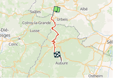

Lengte
28 km

Max. hoogte
924 m

Positief hoogteverschil
1269 m
Km-Effort
44 km

Min. hoogte
360 m

Negatief hoogteverschil
1142 m
Boucle
Neen
Datum van aanmaak :
2018-04-16 23:42:36.154
Laatste wijziging :
2018-04-16 23:42:36.154
5h19
Moeilijkheid : Medium

Gratisgps-wandelapplicatie
 SityTrail
IGN / Geografische instituten
SityTrail Plus
De wereld gaat voor u open
Over ons
Tocht Paard van 28 km beschikbaar op Grand Est, Bas-Rhin, Urbeis. Deze tocht wordt voorgesteld door holtzv.
Plaatsbepaling
Land:
France
Regio :
Grand Est
Departement/Provincie :
Bas-Rhin
Gemeente :
Urbeis
Locatie:
Unknown
Vertrek:(Dec)
Vertrek:(UTM)
365298 ; 5355013 (32U) N.
Opmerkingen