


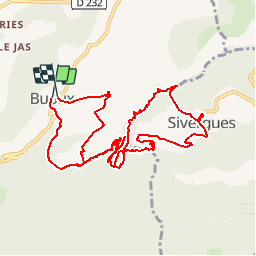
Luberon - Buoux (2 boucles)

uru2010
Gebruiker

Lengte
13,4 km

Max. hoogte
581 m

Positief hoogteverschil
428 m
Km-Effort
19,1 km

Min. hoogte
419 m

Negatief hoogteverschil
435 m
Boucle
Ja
Datum van aanmaak :
2018-04-16 23:50:43.162
Laatste wijziging :
2018-04-16 23:50:43.162
4h33
Moeilijkheid : Medium

Gratisgps-wandelapplicatie
 SityTrail
IGN / Geografische instituten
SityTrail Plus
De wereld gaat voor u open
Over ons
Tocht Stappen van 13,4 km beschikbaar op Provence-Alpes-Côte d'Azur, Vaucluse, Buoux. Deze tocht wordt voorgesteld door uru2010.
Beschrijving
Double boucle depuis Buoux via Sivergues.
Plaatsbepaling
Land:
France
Regio :
Provence-Alpes-Côte d'Azur
Departement/Provincie :
Vaucluse
Gemeente :
Buoux
Locatie:
Unknown
Vertrek:(Dec)
Vertrek:(UTM)
691180 ; 4855877 (31T) N.
Opmerkingen