


2017 touss J2

Airelle
Gebruiker
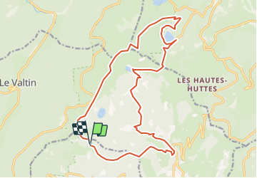

Lengte
20 km

Max. hoogte
1300 m

Positief hoogteverschil
1083 m
Km-Effort
35 km

Min. hoogte
636 m

Negatief hoogteverschil
1064 m
Boucle
Ja
Datum van aanmaak :
2018-04-16 23:57:58.515
Laatste wijziging :
2018-04-16 23:57:58.515
7h00
Moeilijkheid : Onbekend

Gratisgps-wandelapplicatie
 SityTrail
IGN / Geografische instituten
SityTrail Plus
De wereld gaat voor u open
Over ons
Tocht Stappen van 20 km beschikbaar op Grand Est, Haut-Rhin, Stosswihr. Deze tocht wordt voorgesteld door Airelle.
Plaatsbepaling
Land:
France
Regio :
Grand Est
Departement/Provincie :
Haut-Rhin
Gemeente :
Stosswihr
Locatie:
Unknown
Vertrek:(Dec)
Vertrek:(UTM)
355412 ; 5326809 (32U) N.
Opmerkingen