


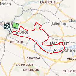
entre vignes et Charente

viam19
Gebruiker

Lengte
16,1 km

Max. hoogte
57 m

Positief hoogteverschil
150 m
Km-Effort
18,1 km

Min. hoogte
7 m

Negatief hoogteverschil
152 m
Boucle
Ja
Datum van aanmaak :
2018-04-17 10:02:20.383
Laatste wijziging :
2018-04-17 10:02:20.383
4h47
Moeilijkheid : Gemakkelijk

Gratisgps-wandelapplicatie
 SityTrail
IGN / Geografische instituten
SityTrail Plus
De wereld gaat voor u open
Over ons
Tocht Stappen van 16,1 km beschikbaar op Nieuw-Aquitanië, Charente, Saint-Brice. Deze tocht wordt voorgesteld door viam19.
Foto's


Plaatsbepaling
Land:
France
Regio :
Nieuw-Aquitanië
Departement/Provincie :
Charente
Gemeente :
Saint-Brice
Locatie:
Unknown
Vertrek:(Dec)
Vertrek:(UTM)
711374 ; 5062949 (30T) N.
Opmerkingen