


chefna_10_17

Mullender
Gebruiker
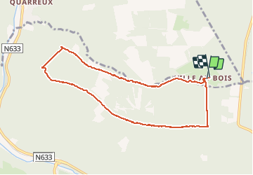

Lengte
8,2 km

Max. hoogte
506 m

Positief hoogteverschil
211 m
Km-Effort
11 km

Min. hoogte
313 m

Negatief hoogteverschil
207 m
Boucle
Ja
Datum van aanmaak :
2018-04-17 10:39:20.867
Laatste wijziging :
2018-04-17 10:39:20.867
1h52
Moeilijkheid : Medium

Gratisgps-wandelapplicatie
 SityTrail
IGN / Geografische instituten
SityTrail Plus
De wereld gaat voor u open
Over ons
Tocht Stappen van 8,2 km beschikbaar op Wallonië, Luik, Aywaille. Deze tocht wordt voorgesteld door Mullender.
Plaatsbepaling
Land:
Belgium
Regio :
Wallonië
Departement/Provincie :
Luik
Gemeente :
Aywaille
Locatie:
Sougné-Remouchamps
Vertrek:(Dec)
Vertrek:(UTM)
697688 ; 5590793 (31U) N.
Opmerkingen