


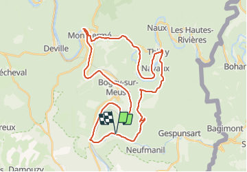
MEUSE Semoy Col du loup

PascalBanide
Gebruiker

Lengte
39 km

Max. hoogte
393 m

Positief hoogteverschil
618 m
Km-Effort
47 km

Min. hoogte
130 m

Negatief hoogteverschil
619 m
Boucle
Ja
Datum van aanmaak :
2018-04-17 10:50:27.661
Laatste wijziging :
2018-04-17 10:50:27.661
6h37
Moeilijkheid : Medium

Gratisgps-wandelapplicatie
 SityTrail
IGN / Geografische instituten
SityTrail Plus
De wereld gaat voor u open
Over ons
Tocht Mountainbike van 39 km beschikbaar op Grand Est, Ardennes, Nouzonville. Deze tocht wordt voorgesteld door PascalBanide.
Plaatsbepaling
Land:
France
Regio :
Grand Est
Departement/Provincie :
Ardennes
Gemeente :
Nouzonville
Locatie:
Nouzonville
Vertrek:(Dec)
Vertrek:(UTM)
627024 ; 5520186 (31U) N.
Opmerkingen