


Blendecques (2) 12.7Km Dén P 137m

alain62rando
Gebruiker
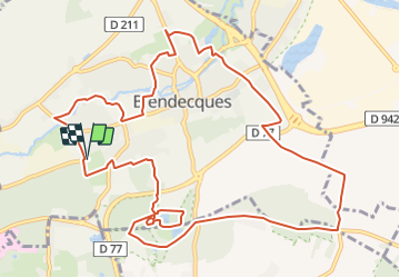

Lengte
12,6 km

Max. hoogte
84 m

Positief hoogteverschil
137 m
Km-Effort
14,4 km

Min. hoogte
9 m

Negatief hoogteverschil
138 m
Boucle
Ja
Datum van aanmaak :
2018-04-17 11:06:04.446
Laatste wijziging :
2019-02-08 06:53:46.513
3h13
Moeilijkheid : Gemakkelijk

Gratisgps-wandelapplicatie
 SityTrail
IGN / Geografische instituten
SityTrail Plus
De wereld gaat voor u open
Over ons
Tocht Stappen van 12,6 km beschikbaar op Hauts-de-France, Pas-de-Calais, Blendecques. Deze tocht wordt voorgesteld door alain62rando.
Beschrijving
Départ Stand de Tir (Aux 2 Lions)
Rando avec 7.7Km de chemins
Plaatsbepaling
Land:
France
Regio :
Hauts-de-France
Departement/Provincie :
Pas-de-Calais
Gemeente :
Blendecques
Locatie:
Unknown
Vertrek:(Dec)
Vertrek:(UTM)
448267 ; 5617988 (31U) N.
Opmerkingen