


IME GB - Journée VTT Itinérante 26 oct 17

norbertmarteau
Gebruiker
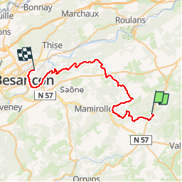

Lengte
41 km

Max. hoogte
667 m

Positief hoogteverschil
710 m
Km-Effort
52 km

Min. hoogte
238 m

Negatief hoogteverschil
1002 m
Boucle
Neen
Datum van aanmaak :
2018-04-17 11:27:12.921
Laatste wijziging :
2018-04-17 11:27:12.921
3h17
Moeilijkheid : Zeer moeilijk

Gratisgps-wandelapplicatie
 SityTrail
IGN / Geografische instituten
SityTrail Plus
De wereld gaat voor u open
Over ons
Tocht Mountainbike van 41 km beschikbaar op Bourgondië-Franche-Comté, Doubs, Étalans. Deze tocht wordt voorgesteld door norbertmarteau.
Plaatsbepaling
Land:
France
Regio :
Bourgondië-Franche-Comté
Departement/Provincie :
Doubs
Gemeente :
Étalans
Locatie:
Verrières-du-Grosbois
Vertrek:(Dec)
Vertrek:(UTM)
293366 ; 5230164 (32T) N.
Opmerkingen