


2017-10-23 1124__20171023_1124.gpx

georgein
Gebruiker
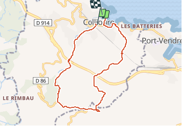

Lengte
8,8 km

Max. hoogte
304 m

Positief hoogteverschil
348 m
Km-Effort
13,5 km

Min. hoogte
4 m

Negatief hoogteverschil
359 m
Boucle
Neen
Datum van aanmaak :
2019-08-04 09:21:01.885
Laatste wijziging :
2020-01-31 20:30:51.154
--
Moeilijkheid : Onbekend

Gratisgps-wandelapplicatie
 SityTrail
IGN / Geografische instituten
SityTrail Plus
De wereld gaat voor u open
Over ons
Tocht Stappen van 8,8 km beschikbaar op Occitanië, Pyrénées-Orientales, Collioure. Deze tocht wordt voorgesteld door georgein.
Plaatsbepaling
Land:
France
Regio :
Occitanië
Departement/Provincie :
Pyrénées-Orientales
Gemeente :
Collioure
Locatie:
Unknown
Vertrek:(Dec)
Vertrek:(UTM)
506798 ; 4707997 (31T) N.
Opmerkingen