Tocht Stappen Nuret-le-Ferron - De vallons en brandes  - Photo
 Phil36
Phil36

Gebruiker

© OpenStreetMap contributors
Lengte
Lengte
13 km
Max. hoogte
Max. hoogte
166 m
Positief hoogteverschil
107 m
Km-Effort
Km-Effort  
14,4 km
Min. hoogte
Min. hoogte
129 m
Negatief hoogteverschil
106 m
Boucle
Boucle
Ja
Datum van aanmaak :
2018-04-17 11:54:31.467
Laatste wijziging :
2018-04-17 11:54:31.467

(0 Bericht)

Stappen
Stappen
2h46
Moeilijkheid : Medium

Scan deze QR-code om de tocht te openen in de SityTrail-applicatie

Gratisgps-wandelapplicatie

Logo SityTrail SityTrail

IGN / Geografische instituten

SityTrail uit de App Store downloaden SityTrail uit Google Play downloaden

Logo SityTrail SityTrail World

De wereld gaat voor u open

SityTrail uit de App Store downloaden SityTrail uit Google Play downloaden SityTrail op Huawei AppGallery downloaden

Over ons

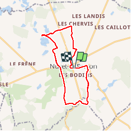
Tocht Stappen van 13 km beschikbaar op Centre-Val de Loire, Indre, Nuret-le-Ferron. Deze tocht wordt voorgesteld door Phil36.

Beschrijving

Départ Nuret-le-Ferron(Balissage jaune) Une ballade agréable .

Hoogteprofiel

Plaatsbepaling

Land:
France
Regio :
Centre-Val de Loire
Departement/Provincie :
Indre
Gemeente :
Nuret-le-Ferron
Locatie:
Unknown
Vertrek:(Dec)
Vertrek:(UTM)
380405 ; 5171165 (31T) N.

Wandeltochten in de omgeving

Tocht Lopen Chasseneuil - PR9 Chasseneuil - Photo
Lopen
pivol

Lopen

Gemakkelijk
(1)
Chasseneuil, Centre-Val de Loire, Indre, France
8 km | 9,3 km-effort
1min
Ja


Sluiten
Mijn abonnementen