


Col du Vial

jlrayon
Gebruiker

Lengte
10,7 km

Max. hoogte
1252 m

Positief hoogteverschil
507 m
Km-Effort
17,5 km

Min. hoogte
833 m

Negatief hoogteverschil
508 m
Boucle
Ja
Datum van aanmaak :
2017-12-02 08:18:55.376
Laatste wijziging :
2017-12-02 08:18:55.376
3h34
Moeilijkheid : Moeilijk

Gratisgps-wandelapplicatie
 SityTrail
IGN / Geografische instituten
SityTrail Plus
De wereld gaat voor u open
Over ons
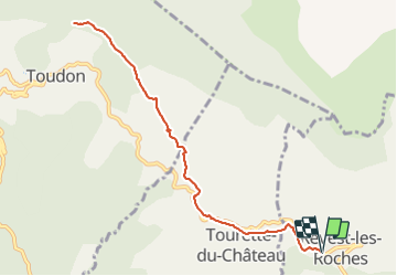
Tocht Stappen van 10,7 km beschikbaar op Provence-Alpes-Côte d'Azur, Alpes-Maritimes, Revest-les-Roches. Deze tocht wordt voorgesteld door jlrayon.
Beschrijving
Revest-les-Roches, col du Vial en AR
Plaatsbepaling
Land:
France
Regio :
Provence-Alpes-Côte d'Azur
Departement/Provincie :
Alpes-Maritimes
Gemeente :
Revest-les-Roches
Locatie:
Unknown
Vertrek:(Dec)
Vertrek:(UTM)
351825 ; 4860369 (32T) N.
Opmerkingen