


171130AISEMONT (Gp2)

DANIELVGL
Gebruiker
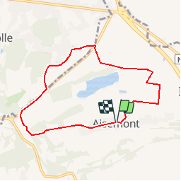

Lengte
6,9 km

Max. hoogte
200 m

Positief hoogteverschil
122 m
Km-Effort
8,6 km

Min. hoogte
124 m

Negatief hoogteverschil
122 m
Boucle
Ja
Datum van aanmaak :
2018-04-17 13:43:29.007
Laatste wijziging :
2018-04-17 13:43:29.007
50m
Moeilijkheid : Medium

Gratisgps-wandelapplicatie
 SityTrail
IGN / Geografische instituten
SityTrail Plus
De wereld gaat voor u open
Over ons
Tocht Lopen van 6,9 km beschikbaar op Wallonië, Namen, Fosses-la-Ville. Deze tocht wordt voorgesteld door DANIELVGL.
Plaatsbepaling
Land:
Belgium
Regio :
Wallonië
Departement/Provincie :
Namen
Gemeente :
Fosses-la-Ville
Locatie:
Aisemont
Vertrek:(Dec)
Vertrek:(UTM)
617360 ; 5584973 (31U) N.
Opmerkingen