


Test JCPMF FLV 10 kms

DANIELVGL
Gebruiker
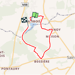

Lengte
10 km

Max. hoogte
279 m

Positief hoogteverschil
131 m
Km-Effort
11,8 km

Min. hoogte
228 m

Negatief hoogteverschil
133 m
Boucle
Neen
Datum van aanmaak :
2018-04-17 14:22:49.432
Laatste wijziging :
2018-04-17 14:22:49.432
--
Moeilijkheid : Medium

Gratisgps-wandelapplicatie
 SityTrail
IGN / Geografische instituten
SityTrail Plus
De wereld gaat voor u open
Over ons
Tocht Lopen van 10 km beschikbaar op Wallonië, Namen, Fosses-la-Ville. Deze tocht wordt voorgesteld door DANIELVGL.
Plaatsbepaling
Land:
Belgium
Regio :
Wallonië
Departement/Provincie :
Namen
Gemeente :
Fosses-la-Ville
Locatie:
Fosses-la-Ville
Vertrek:(Dec)
Vertrek:(UTM)
619758 ; 5581493 (31U) N.
Opmerkingen