


Grand Paradis - J3

saphile
Gebruiker
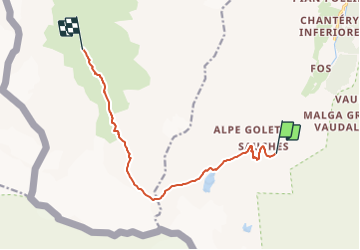

Lengte
10,2 km

Max. hoogte
3087 m

Positief hoogteverschil
823 m
Km-Effort
21 km

Min. hoogte
2267 m

Negatief hoogteverschil
829 m
Boucle
Neen
Datum van aanmaak :
2018-04-17 14:30:21.639
Laatste wijziging :
2018-04-17 14:30:21.639
4h15
Moeilijkheid : Moeilijk

Gratisgps-wandelapplicatie
 SityTrail
IGN / Geografische instituten
SityTrail Plus
De wereld gaat voor u open
Over ons
Tocht Stappen van 10,2 km beschikbaar op Valle d'Aosta, Onbekend, Rhêmes-Notre-Dame. Deze tocht wordt voorgesteld door saphile.
Beschrijving
Grand Paradis 2018 - J3


Plaatsbepaling
Land:
Italy
Regio :
Valle d'Aosta
Departement/Provincie :
Onbekend
Gemeente :
Rhêmes-Notre-Dame
Locatie:
Unknown
Vertrek:(Dec)
Vertrek:(UTM)
350383 ; 5042014 (32T) N.
Opmerkingen