


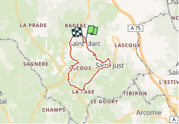
Saint-Marc

josy31
Gebruiker

Lengte
11,1 km

Max. hoogte
1060 m

Positief hoogteverschil
259 m
Km-Effort
14,6 km

Min. hoogte
913 m

Negatief hoogteverschil
258 m
Boucle
Ja
Datum van aanmaak :
2018-04-17 15:52:54.979
Laatste wijziging :
2018-04-17 15:52:54.979
3h15
Moeilijkheid : Gemakkelijk

Gratisgps-wandelapplicatie
 SityTrail
IGN / Geografische instituten
SityTrail Plus
De wereld gaat voor u open
Over ons
Tocht Stappen van 11,1 km beschikbaar op Auvergne-Rhône-Alpes, Cantal, Val d'Arcomie. Deze tocht wordt voorgesteld door josy31.
Plaatsbepaling
Land:
France
Regio :
Auvergne-Rhône-Alpes
Departement/Provincie :
Cantal
Gemeente :
Val d'Arcomie
Locatie:
Saint-Marc
Vertrek:(Dec)
Vertrek:(UTM)
515165 ; 4972107 (31T) N.
Opmerkingen