


M66 - Millas força réal col del Bou - Montner

jeff66
Gebruiker
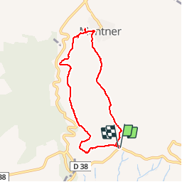

Lengte
7,4 km

Max. hoogte
322 m

Positief hoogteverschil
228 m
Km-Effort
10,4 km

Min. hoogte
122 m

Negatief hoogteverschil
228 m
Boucle
Ja
Datum van aanmaak :
2018-04-17 16:06:17.762
Laatste wijziging :
2018-04-17 16:06:17.762
1h35
Moeilijkheid : Medium

Gratisgps-wandelapplicatie
 SityTrail
IGN / Geografische instituten
SityTrail Plus
De wereld gaat voor u open
Over ons
Tocht Stappen van 7,4 km beschikbaar op Occitanië, Pyrénées-Orientales, Millas. Deze tocht wordt voorgesteld door jeff66.
Beschrijving
M66 - Millas força réal col del Bou - Montner - le 12.01.2018
Plaatsbepaling
Land:
France
Regio :
Occitanië
Departement/Provincie :
Pyrénées-Orientales
Gemeente :
Millas
Locatie:
Unknown
Vertrek:(Dec)
Vertrek:(UTM)
474042 ; 4730638 (31T) N.
Opmerkingen