


brie/chalais 23 janv 2018

bert16
Gebruiker
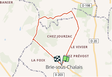

Lengte
6,9 km

Max. hoogte
175 m

Positief hoogteverschil
135 m
Km-Effort
8,7 km

Min. hoogte
79 m

Negatief hoogteverschil
134 m
Boucle
Ja
Datum van aanmaak :
2018-04-17 16:49:02.009
Laatste wijziging :
2018-04-17 16:49:02.009
1h25
Moeilijkheid : Gemakkelijk

Gratisgps-wandelapplicatie
 SityTrail
IGN / Geografische instituten
SityTrail Plus
De wereld gaat voor u open
Over ons
Tocht Stappen van 6,9 km beschikbaar op Nieuw-Aquitanië, Charente, Brie-sous-Chalais. Deze tocht wordt voorgesteld door bert16.
Beschrijving
Association des anciens élèves et amis de Brie-sous-chalais 16210
mardi de 14h à 16h
Plaatsbepaling
Land:
France
Regio :
Nieuw-Aquitanië
Departement/Provincie :
Charente
Gemeente :
Brie-sous-Chalais
Locatie:
Unknown
Vertrek:(Dec)
Vertrek:(UTM)
265334 ; 5022335 (31T) N.
Opmerkingen