


2018 02 03 Cross Shauenberg Exa

staubalex
Gebruiker
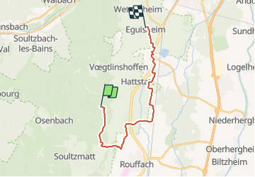

Lengte
18,2 km

Max. hoogte
506 m

Positief hoogteverschil
201 m
Km-Effort
22 km

Min. hoogte
190 m

Negatief hoogteverschil
423 m
Boucle
Neen
Datum van aanmaak :
2018-04-17 17:42:50.323
Laatste wijziging :
2018-04-17 17:42:50.323
1h24
Moeilijkheid : Medium

Gratisgps-wandelapplicatie
 SityTrail
IGN / Geografische instituten
SityTrail Plus
De wereld gaat voor u open
Over ons
Tocht Andere activiteiten van 18,2 km beschikbaar op Grand Est, Haut-Rhin, Pfaffenheim. Deze tocht wordt voorgesteld door staubalex.
Plaatsbepaling
Land:
France
Regio :
Grand Est
Departement/Provincie :
Haut-Rhin
Gemeente :
Pfaffenheim
Locatie:
Unknown
Vertrek:(Dec)
Vertrek:(UTM)
370510 ; 5317077 (32T) N.
Opmerkingen